
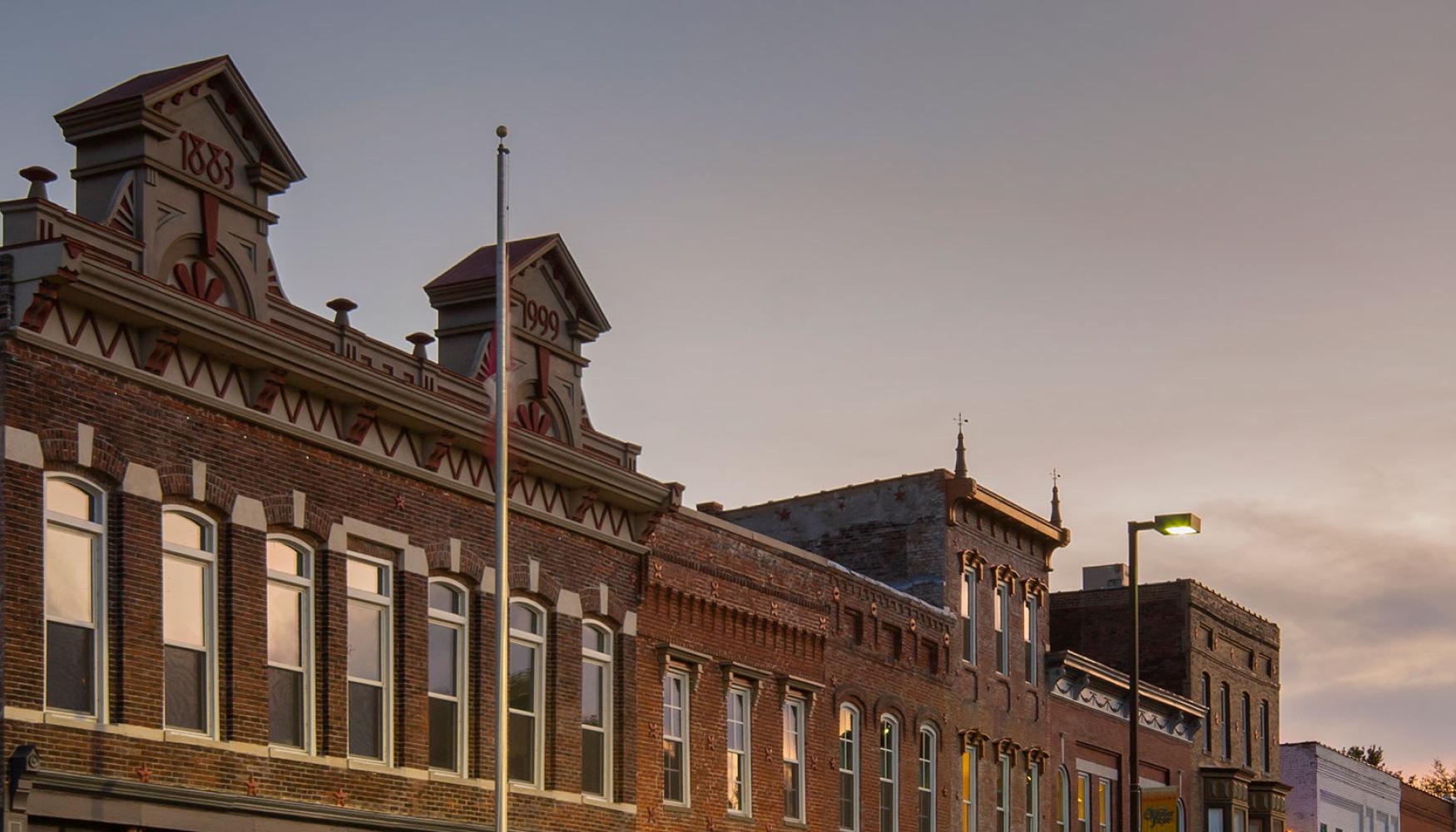


Our Common Neighborhood - The Riverfront
The next generation is really why we're here today... The riverfront is the one common neighborhood for everyone in this area. The one neighborhood that everyone shares is the river, because afterall, that is how Paducah got here. The great old river is replete with history of the United States of America. I want to help the community enhance the river experience so that this common neighborhood that everyone has will be a place to go and enjoy yourself for years and years to come.
-- U.S. Senator Mitch McConnell (August 28, 2006 on Paducah's Riverfront)
BUILD Grant
The City of Paducah is receiving significant funding through the Better Utilizing Investments to Leverage Development (BUILD) Grant program. In July 2019, the City submitted a grant application to the U.S. Department of Transportation requesting funding to improve various transportation elements along the downtown riverfront.
Paducah will be receiving $10.4 million for the Riverfront Commons project which includes
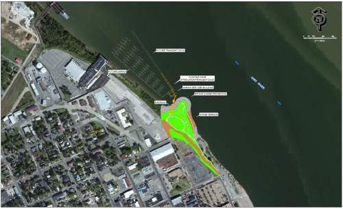
- Riverboat Excursion Pier and Plaza - The Riverboat Excursion Pier and Plaza was identified in the 2007 Riverfront Master Plan as one of many projects to enhance Paducah’s riverfront. The pier will provide a docking point for the riverboats that visit Paducah. Currently, visitors disembark and must climb a steep slope from the Foot of Broadway in order to access the downtown area. The installation will provide a safer and easier transition from boat to land, allow for more secure riverboat dockings, and move the disembarkation point out of the flow of traffic at the Foot of Broadway.
- Bike, Pedestrian, and Broadband Linkages - Bike, Pedestrian, and Broadband Linkages will include the development of a multi-use path from 6th Street along Park Ave/3rd Street into downtown to aid in the movement of pedestrian/bike traffic from the Convention Center/Dome to downtown. Key intersection improvements, including curb extensions, wayfinding, bus shelters and crosswalks, will make for an improved pedestrian experience. A broadband installation along the riverfront will allow for emergency call boxes, security cameras, and hardline internet access for the transient boat dock.
- Improvements to the landing near the Transient Boat Dock - The Transient Boat Landing improvements include connecting sidewalks from the floodwall to Greenway Trail, improving traffic control, adding landscaping to prevent erosion and providing shade, wayfinding, and amenities for users of the transient boat dock.
- Paducah Commons 2015 Master Plan
-
The Paducah Commons Small Area Master Plan covers an approximately six square block area located on the Paducah riverfront between the Convention Center and the rehabilitated Schultz Park and transient dock. The site is key in that it exists adjacent to the Holiday Inn Paducah Riverfront which opened in 2017. The park will act as a major transition between Downtown Paducah and the Convention Center. The City is interested in how the space may be used as a new park and how the park may connect the Riverfront as a spur to private redevelopment in Lowertown and from the Convention Center to Downtown. The master plan, which was completed in 2015, has the following goals:
Blending the new park into the overall city development pattern, Facilitating pedestrian and vehicular traffic from the riverfront to the downtown core and back,
The process was a collaborative effort between RATIO’s project design team and the Paducah riverfront stakeholders of neighborhood, community and business leaders.
- Accommodating and extending the City’s proposed greenway trail, and
- Formally deciding on appropriate uses in order to craft an implementable plan.
- Project Actions and Timeline
-
- Riverfront Park Mitigation Project - Environmental Assessment completed with construction underway. Due to heavy rains in 2018 and 2019, the Paducah Riverfront Park sustained damage from flooding. This is the area surrounding the existing revetment just upstream of the transient boat dock. The City of Paducah filed a grant application for Federal Emergency Management Agency (FEMA) Disaster Relief funding to repair the damaged shoreline. FEMA conducted an Environmental Assessment (EA) to analyze the effects of alternatives related to the damaged shoreline's proposed armoring. The City is publishing a Public Notice to inform the public of the proposed action and associated draft EA.
- Completed Greenway Trail Phase V during summer of 2020. Improved traffic flow, enhanced Schultz Park with lighting and landscaping, and added trail from Jefferson Street through Schultz Park along the riverfront.
- ONGOING PROJECT: Applied for BUILD Grant in July 2019 with notice of receiving $10.4 million award in November 2019.
- Applied for 2018 BUILD Grant
- Paducah Transient Boat Dock and gangway opened to the public on September 21, 2017.
- 2016-2017 -- Finishing of surface of park, construction of revetment, and construction of transient dock and gangway.
- On November 23, 2015, Governor Steve Beshear ceremonially presented $1.525 million in state funding to support Paducah’s Riverfront Redevelopment Project. Check Presentation Ceremony (17 minutes)
- Approval of an $8.11 million contract with MAC Construction & Excavating at the October 20, 2015, meeting of the Paducah Board of Commissioners for the construction of Phase I-B. Project will include the finishing of the park and installation of the gangway and 340 feet of transient dock.
- Re-advertisement for bids for construction of Phase I-B. Bid opening September 9, 2015.
- Advertisement for bids for construction of Phase I-B. Bid opening May 27, 2015, resulted in bids much higher than available grant funding leading the City to modify project slightly and resubmit to State for approval. Main change will be to require structural steel for the transient dock rather than the option of either steel or concrete.
- May 2015, agreement with Kentucky Transportation approved for the administration of Federal Highway Administration funds in the amount of $3,920,000.
- April 2015, received approval from the Kentucky Transportation Cabinet to move forward on project.
- During 2014, monitored the settling rate, if any, of the rock base and worked on getting State approval for plan amendments as recommended by PRDA and the City Commission.
- PRDA presented findings of months of review including the Riverfront Development Report-Study Recommendations at the April 15, 2014 City Commission meeting.
- In spring 2014, began monitoring the settling rate, if any, of the rock base for the park extension.
- PRDA held meetings approximately twice a month from October 2013 through April 2014 to review each element of the project.
- Ohio River Boat Launch scheduled to be completed in November 2013. Ribbon cutting set will be held in Spring 2014 at the boat launch located at 6th and Burnett Streets.
- Steel pilings completed in October 2013 with majority of mass fill completed and in settling phase.
- Review of Riverfront Redevelopment Project assigned to Paducah Riverfront Development Advisory Board (PRDA) in September 2013.
- Construction began in May 2013 for Ohio River Boat Launch project and mass fill/steel piling project.
- Advertisement for bids for Schultz Park mass fill project. Bid opening on April 4, 2013.
- Advertisement for bids for Ohio River Boat Launch project. Bid opening on March 26, 2013.
- Infill Ceremony held November 2, 2012, to kick off project.
- Relocation of mussels in October 2012.
- The Finding of No Significant Impact (FONSI) document was approved in July 2012 by the Kentucky Transportation Cabinet (KYTC and the Federal Highway Administration (FHWA).
- The Biological Opinion (BO) document from the U.S. Fish & Wildlife Service on impacts to freshwater mussels at the boat launch and marina/transient dock locations was approved in June 2012.
- The Environmental Assessment (EA) document (see more information below) was approved in April 2012 by the Kentucky Transportation Cabinet and the Federal Highway Administration.
- Project Video Updates
-
February 2017: On this Tell Me More episode, City Engineer & Public Works Director Rick Murphy explains the process to construct the 340-foot long transient dock. Video is from February 10, 2017.
September 2016: This is aerial footage of the Riverfront Redevelopment Project taken in mid-September 2016. It shows the base of the large park, the revetment (stone steps), and the pilings for the gangway and transient dock which will arrive in November 2016. Thank you to Bacon, Farmer, Workman Engineering and Testing for providing the video.
November 2012: On November 2, 2012, the City held an infill ceremony with the tossing of colored sand to represent the building of a new land mass to expand Schultz Park. The first step of the project was to build an approximate 3-acre land mass into the Ohio River just downstream of the existing Schultz Park. Construction commenced in the summer of 2013 to build the park base. The project had to be moved downstream due to a high concentration of mussels. The mussels in the new project area have been relocated. Speakers at the ceremony included former Mayor Bill Paxton, Parks Services Director Mark Thompson, PRDA Board Member Joe Framptom, and Engineering-Public Works Director Rick Murphy.
- Riverfront Redevelopment History
-
In June 2005, City of Paducah planning staff encouraged the Paducah City Commission to consider developing a quality waterfront master plan to plan for future development on the river and to show federal delegates this community’s serious commitment to riverfront redevelopment as a means to increase local tourism and spur economic development. Following on the heels of the success of the Luther F. Carson Center, the Commission agreed and authorized staff to hire a consultant to help the City with a riverfront redevelopment master plan.
By 2006, local elected officials were thanking Senator Mitch McConnell for $5.3 million in federal funds for the improvement of Paducah’s riverfront area. The City secured more than $6 million in additional funding and worked through the extensive permitting process. The original plan has changed due to the presence of mussels in the Ohio River and the consensus to shift part of the project 500 feet downstream.
Redeveloping Paducah’s riverfront will take several phases to complete. Phase I-A was completed in 2013. This phase expanded Schultz Park by adding approximately 230,000 cubic yards into t
 he Ohio River and installed the base of the transient dock gangway (12, 36-inch steel pilings). The fill needed to settle at least nine months before the next construction phase could begin. This park expansion creates a downstream harbor that protects the transient dock and could be the site of a future marina.
In 2015, Phase I-B was initiated to complete the surface of the park and the 20-foot wide, 340-foot long transient dock that is capable of being extended to 1200 feet in length in later phases. This transient dock provides boats of all sizes a location to dock and enjoy downtown Paducah by providing fuel, power, and sewer facilities. Phase I-B was completed in the summer of 2017.
In March 2013, the project to construct a new boat launch facility with an 85-space parking/trailering lot at 6th and Burnett just downstream of the Paducah Expo Center began. This project was completed in December 2013. The Ohio River Boat Launch includes a five- to six-lane boat ramp with a gangway/courtesy dock. The project also included improvements to Burnett Street from North 8th Street to North 6th Street over the floodwall to the new parking area and additional amenities consisting of landscaping and drainage improvements. The facility has cameras and lighting.
- Planning and Public Outreach - 2005 to 2012
-
New accordion content
- Recommendation for project (2005)
- Meeting with U.S. Corps of Engineers (January 2006)
- Project scoping meetings with City staff, executive committee, stakeholders, and the public (March 2006)
- Bus tour of Chattanooga and Evansville riverfronts (March 2006)
- Public meeting to present riverfront opportunities (May 2006)
- Submission of Preliminary Riverfront Plan (June 2006)
- Meetings with riverfront property owners (July 2006)
- Meetings with regulatory and river industries (August 2006)
- Check presentation by U.S. Senator Mitch McConnell at riverfront (August 2006)
- Revised Preliminary Riverfront Plan (September 2006)
- Adoption of Riverfront Redevelopment Plan by Paducah City Commission (April 2007)
- Public informational display installed at Schultz Park (May 2008)
- Meetings with various regulatory agencies (2006-present)
- Advertisement for Section 106 consulting parties (January 2010)
- Public meeting to discuss Environmental Assessment (March 2010)
- Public hearing for Environmental Assessment (May 2012)
- Environmental Assessment and Mussels - 2012 Approval
-
As required under the National Environmental Policy Act (NEPA) of 1969, Federal agencies must consider the impacts ot the ecological, social, and cultural environments. Since the Riverfront Redevelopment Project was funded through state and federal grants, the environmental impacts must be documented in an Environmental Assessment (EA) or an Environmental Impact Statement (EIS). The EA, approved by the Kentucky Transportation Cabinet (KYTC) and the Federal Highway Administration (FHWA) in April 2012, was presented at a public hearing on May 30, 2012. Public comments were incorporated into Finding of No Significant Impact (FONSI).
Video from May 30, 2012 Public Hearing for Riverfront Project
Environmental Assessment Document (Approved April 2012) Appendices
The Environmental Assessment document above is not the first one completed for this project. A document was completed in November 2009; however, a petition was filed by an organization against the project location due to the concentration of mussels, some of which could be endangered, found in the Ohio River. To satisfy the petitioner and limit the disturbance and mitigation of mussels, the project was moved 500 feet downstream. This necessitated the completion of a new EA document, the one approved in April 2012.