

Contact
Drainage in Paducah
The majority of the City’s drainage problems originates from natural geography since Paducah is located on the Ohio River’s floodplain. Nearly 204,000 square miles of land drain to Paducah.
Regarding infrastructure, Paducah has 110 miles of storm sewer and 69 miles of combined sewer. Much of the city’s development occurred at a time when storm water management was not a priority and the current development ordinances were not in place. The current storm water system is aging, does not meet capacity needs, and needs to be upgraded and/or replaced. The majority of the storm sewers are 60 to 100 years old.
Following the historic storm event on July 7, 2015, the City decided in 2016 to move forward with the development of a comprehensive storm water master plan to study and model the existing storm water management system in detail, establish project goals, and prioritize projects. The master plan also would look at possible ways to fund system upgrades. The previous study was completed in 1989 and looked at only five flood-prone areas.
Recent Project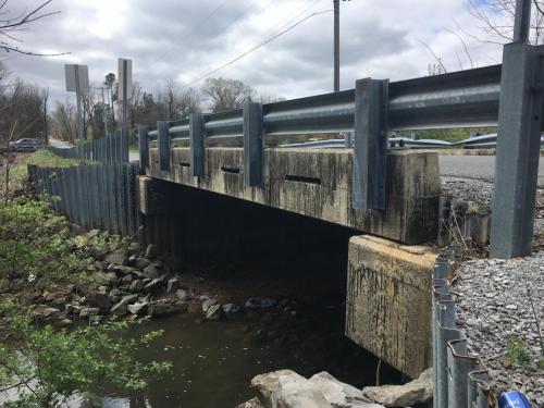
Buckner Lane Bridge Replacement and Crooked Creek Mitigation Project This comprehensive project improved the two-lane section of Buckner Lane between Hansen Road and Pecan Drive and replaced the dilapidated bridge (pictured) that had been affected by flooding and severe weather events. The project replaced the Buckner Lane bridge over Crooked Creek near the intersection with Buckner Lake Circle and installed a larger box culvert under Oakcrest Drive near the intersection with Buckner Lane. Since the bridge’s hydraulic opening was enhanced, it is improving the flow during flood conditions and reducing the number of times that floodwaters from Crook Creek overtop the roadway during high rain events. Also, the drainage ditch adjacent to Buckner Lane is improved by lining it with concrete to enhance stormwater flow and reduce overgrowth.
The project also improves Buckner Lane's roadway by increasing the lane widths, adding four-foot wide shoulders, and paving. The entrance to Buckner Lake Circle also has been improved.
The bid opening for this project was March 23, 2022, with the Paducah Board of Commissioners approving a contract with Jim Smith Contracting on April 26, 2022. Construction began May 31, 2022. The construction contract was closed out in July 2023.
Additional Stormwater Projects
Comprehensive Storm Water Master Plan
The City of Paducah contracted in March 2017 with Strand Associates, Inc. with the assistance of Paducah-based Bacon Farmer Workman Engineering & Testing, Inc. to complete the Comprehensive Stormwater Master Plan for Paducah. Read the Comprehensive Stormwater Master Plan Executive Summary.
“The goal of the Master Plan is not to eliminate flooding. The goal is to mitigate flooding, to manage flooding—to find a balance between costs and benefits achieved. It’s a difficult conversation. In a perfect world, no one would flood.”
- Master Plan Phases and Top Projects
-
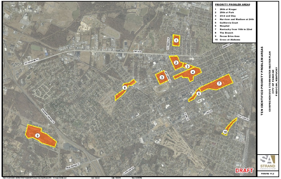 Phase I - The Master Plan’s first phase used the July 7, 2015, storm event to create a model of Paducah’s natural and manmade infrastructure including storm and combined sewer systems, topography, drainage basins, and river systems. This computer model along with community input was used to determine flood-prone areas in Paducah. The Master Plan’s first phase identified approximately $43 million in flood mitigation projects located within ten priority areas. If the drainage projects outlined in the ten project areas were completed, 245 homes in the City would not be flooded with an additional 289 structures seeing a reduction in flooding.
Phase II - The Master Plan’s second phase included the development of annual operation and maintenance costs and the costs for repair and replacement of existing infrastructure, the projection of future funding needs, funding alternatives and rate options, billing system options, a rate comparison, and a storm water utility ordinance. It specifically addresses the creation of a Stormwater Utility with an associated Stormwater Impact Fee. The proposed Fee is a revenue stream that could fund items including the ten drainage projects identified in the first phase of the plan development, operations and maintenance of the existing infrastructure, the City’s flood protection system (floodwall), regulatory compliance requirements, infrastructure repair and replacement, and the administration of the program through staffing and equipment. There are approximately 1500 stormwater utilities in the United States with 12 of them in Kentucky.
The consultant team also worked with a citizen advisory group, the Storm Water Advisory Committee (SWAC), to solicit feedback on the priority areas, mitigation options, and level of service to be used for sizing alternatives. General cost and design differences for levels of service ranging from 10-year, 25-year, and 100-year storm events were shared with the SWAC to help inform decision making that led to the selection of a 25-year storm event as the basis of design.
- What is a Stormwater Utility and Infrastructure Fee?
-
Stormwater Utilities and an associated Infrastructure Fee would be a dedicated funding source for the City of Paducah to solve drainage problems, to repair, maintain, and enhance existing storm infrastructure, to provide flood protection, and to comply with federal regulatory requirements associated with water quality.
Most storm water utilities use the Equivalent Residential Unit (ERU) as their method of funding storm water projects and operations. Using the ERU method, a property would be charged a monthly storm water fee based on its contribution to storm water runoff which is directly related to the amount of impervious surface on a property. In Kentucky, several communities have a monthly fee ranging from $1.50 to more than $7.00 to fund their storm water utilities. In 2016, the State average was $3.60 per month for residential properties. Nationally, there are approximately 1500 storm water utilities.
Note: This fee was proposed in 2019. It has not been implemented.
Paducah proposed a Stormwater Infrastructure Fee of $6.13 per month per Equivalent Residential Unit (ERU). Using a sample of 50 residential parcels in Paducah, the average amount of impervious area per residential parcel is 3500 square feet. It was proposed that each residential parcel would pay the same amount, one ERU ($6.13 per month). However, the calculations are more complex for non-residential parcels. Non-residential parcels such as commercial entities would pay a monthly fee equal to the total amount of impervious area on the property divided by 3500 and then multiplied by the proposed fee of $6.13 per month. The fee could generate $2.7 million annually.
Stormwater Infrastructure Fee FAQs
A presentation was provided at the May 21, 2019, Public Meeting that provides an overview of the fee development and the master planning process. Stormwater Public Meeting Slide Presentation (from May 21, 2019)
- Master Plan Timeline
-
- 2019 - A public meeting about the proposed Paducah Stormwater Infrastructure Fee was held May 21, 2019, at the Julian Carroll Convention Center. Property owners met with the team members to see how the proposed fee would impact them.
- 2019 – February 12 presentation at Board of Commissioners meeting by Principal-In-Charge/Senior Planning Advisor John Lyons with Strand Associates regarding the creation of a Stormwater Utility with an associated Stormwater Impact Fee.
- 2018 - Public Meeting No. 4 was held November 14, 2018, at City Hall for residents to provide input regarding the creation of a stormwater utility and associated fee structure. Residents learned how the City plans to fund ten priority drainage projects and existing infrastructure maintenance through the development of a citywide stormwater utility. Below is the video from the meeting.
- 2018 – November 13 discussion by Board of Commissioners with presentation by Strand Associates about Master Plan Phase II, the development of storm water utility.
- 2018 – October 23 discussion by Board of Commissioners with a presentation by Stand Associates on the completion of the first phase of the Comprehensive Stormwater Master Plan. Phase I included the public engagement, the development of the baseline model using the flood information from the 2015 storm event and information from residents, the determination of 23 problem areas for flooding, and the selection of ten of those areas to be priority projects.
- 2018 – Public Meeting No. 3 was held July 30, 2018, at the Paducah Middle School Cafeteria to review the Master Plan progress, selection of the 10 priority project areas, and development of the flood mitigation alternatives.
- 2018 – July 10 discussion by Board of Commissioners with a presentation by Strand Associates. The Comprehensive Storm Water Master Plan development is on schedule with the first phase wrapping up and the second phase initiated. Slide Presentation (July 10, 2018)
- 2018 – March 13 approval by Board of Commissioners for a technical services agreement with Strand Associates, Inc. for Phase II of the Comprehensive Storm Water Master Plan.
- 2017 – December 12 discussion by Board of Commissioners regarding Master Plan’s Phase I work specifically using a variety of data sources to create an existing conditions baseline model of the Paducah area. Extensive public outreach was initiated in order to gather the vital data including the two public meetings, online survey and email access, news releases, social media posts, and 700 flyers. The next step in this phase of the Master Plan process involves reviewing the 23 problem areas and establishing ten priority areas for evaluation. Slide Presentation (December 12, 2017)
- 2017 – Public Meeting No. 2 was held November 13, 2017, at the Robert Cherry Civic Center for an update on the Master Plan’s progress. Residents provided feedback on the accuracy of draft maps and digital imagery reflecting modeling efforts to recreate Paducah’s natural and manmade infrastructure including storm and combined sewer systems, topography, drainage basins, and river systems.
- 2017 – Public Meeting No. 1 was held June 19, 2017, at the Robert Cherry Civic Center to learn about the Master Plan and for residents to share firsthand accounts of flooding on their property and surrounding areas. Approximately 65 Paducah and McCracken County residents attended this meeting.
- 2017 – March 17 approval by the Board of Commissioners for a Technical Services Agreement with Strand Associates, Inc. for the Comprehensive Storm Water Master Plan development. Strand has been in existence since 1946. It has 380 employees and 11 offices including two in Kentucky. Strand has extensive experience in community and storm water modelling and master planning.
- 2017 – February 28 presentation to the Board of Commissioners by Strand Associates and BFW with an overview of how the Master Plan will be developed. Slide Presentation (February 28, 2017
- 2016 – City solicited a request for qualifications from experienced consulting engineering firms for the development of a Comprehensive Stormwater Master Plan. The deadline was June 17, 2016. Six firms submitted their qualifications.
Request for Qualifications Information for Stormwater Master Plan
City of Paducah Code of Ordinances Chapter 50 Floods
1961 Sanitary, Storm, and Combined Sewers Master Plan Report
1989 Stormwater Drainage Study
2015 SMS4 Annual Compliance Report
Cover Letter
Appendix A
Appendix B
Appendix C
Appendix D
Appendix E
- 2016 – February 16 discussion by Board of Commissioners to move forward with Request for Proposals for company to assist in creation of Storm Water Master Plan. Slide Presentation (February 16, 2016)
- 2015 – Historic storm event on July 7.